

Sequoia, Kings Canyon and Channel Islands National Parks - California

Feeding freenzy in the Santa Barbara Channel
A “feeding frenzy”, that’s what Captain Dave says we are witnessing. Thousands of pelicans, gulls, and cormorants are circling and diving into the Ocean. They are noisy too. Hundreds of dolphins and California Sea Lions are “dancing” through the commotion. Obviously, the fish are abundant. Never seen anything like it – probably never will again. We are in the middle of the Santa Barbara Channel headed back to Ventura after visiting the remote Channel Islands National Park.
We decided to help Val, our friend, celebrate her birthday in Cambria. She has had more than her share of family loss. So, it is time to visit her “favorite hotel”. Our trip morphed to include three more National Parks toward our 58 Park goal: Channels Islands, Sequoia, and Kings Canyon. A fantastic way to spend eight fall days - 2011.
Day One and Two – Channel Islands via LA
Would the fog lift and would we make it in time for our 9am, Island Packer departure to San Cruz Island? Those are our questions as we drive from LA to Ventura. Yes and yes. We quickly discover that in addition to Jim, our Denver friend and John, Val’s boyfriend, 100 5th graders are joining us downstairs – adults upstairs. Upon departure, they begin endlessly screaming as the boat crashes through ocean swells on our 21 mile crossing.

Santa Cruz Island, Channel Islands National Park
As we get closer, jagged Santa Cruz Island rises above the channel. The largest of the five Channel Islands, at 96 square miles, it was formed by the Pacific plate and the North American continent slowly colliding, five million years ago. We dock in the sparse harbor. As we disembark we are told not to miss the 4pm departure or we will be stuck all night – primitive camping only.
Santa Cruz Island has an eclectic history, reflected in the unique visitor center (14th stamp!). Inhabited by the native Chumash for decades, Santa Cruz Island was used for ranching more recently. After the National Park was created in 1980, thousands of sheep and boar were removed, returning Santa Cruz to its natural state. 150 unique species now live in and around the islands even though they appear fairly barren. The most visible is the Island Fox - so tiny and cute.
Hiking and kayaking are the perfect activities in the Islands. Unfortunately, our hiking is limited because Tom is still healing from his femur fracture. So, we are happy to join Bob, an enthusiastic volunteer, on a nature walk and talk ending at a spectacular vista overlooking the Pacific.
The trip back is warm and calm making it easy to spot a large humpback whale - surfacing and spouting. I am so excited - just like a little kid. What a thrill, a whale sighting followed by the “feeding frenzy”.
Once ashore, Tom, Jim, and I head to Santa Barbara (a four hour drive). We arrive at the “five star” dog park at Hendry’s Beach just in time for sunset. I have eaten at The Boathouse (right on the beach) before, and am happy to be back. Tom and I share their wonderful whiskey crab chowder, and Morrow Bay oysters.
Day Three – Santa Barbara

Courthouse and clock tower, Santa Barbara, CA
Jim and I discover a “Masters Exhibit” - Van Gough, Degas, and Cezanne - at the Santa Barbara Museum of Art on our morning "power walk" up State Street. After we get Tom off another conference call we go back to visit. Our next stop is the classic Mission Style Courthouse still in use today. An impromptu tour of the original clock being restored and a 360 degree view from the tower are a real treat. Then we enjoy lunch at the fabulous Biltmore overlooking the Ocean. “It’s a nice spot for a $21 hamburger”, as Tom says.
A three hour drive takes us along the coast to Cambria. John and Val, the birthday girl, happily greet us on our lovely ocean front patio.
Day Four and Five – Cambria

Ocean view from the Blue Dolphin Inn, Cambria, CA
Cambria is a charming, upscale beach town 6 miles south of San Simeon. The nicely appointed Blue Dolphin Inn sits right on Moonstone Beach Drive. We have all three ground level ocean facing rooms so the entire patio is ours. Warm sunshine, rocky seascapes, and sweet smelling blossoms all create a magical setting for Val’s birthday.
Our “feeding frenzy” begins with Happy Hour on the patio followed by dinner at Hoppe’s Bistro and Wine Bar in nearby Cayucos. Although a bit chilly, we dine in “the garden”. My singing scallops and gazpacho soup are superb and Val enjoys wine pairings. We end the evening back on the patio for birthday cake. The “frenzy” continues the next day with breakfast on the patio followed by lunch at Robins in Cambria. Dinner at The Black Cat, also in Cambria, is the perfect finale – with Mathew as the perfect waiter.
The first two days in Cambria, moist fog does not lift until 2pm. But, the third day we awake to clear skies. We love walking the wooden boardwalk along the rocky coastline – seals, tide pools, and a falcon are such fun to see. A “scarecrow festival”, celebrating Halloween, really showcases the community’s creativity.

Elephant Seal at Piedras Blancas
We couldn’t leave without my favorite past time watching the enormous Elephant Seals at Piedras Blancas. Once nearly extinct, there are now 16,000 in this area alone. Today the young males are “practicing “their fighting skills. (We returned in January 2012 to see hundreds of new pups – what an experience.)
Feeling “ocean deficient”, I could have lingered longer in this beautiful setting. But, we said our “goodbyes” to Jim, Val, John and the ocean. The barren hills take us immediately inland through the hot San Joaquin Valley toward Kings Canyon and Sequoia National Park Complex. Golden fields of wheat and miles of cotton crops are accompanied by signs saying “no water no jobs. It is odd to see such water dependent crops in an arid location.
Highway 198 takes us to the south entrance of Sequoia National Park. As we approach the mountains, smog becomes more apparent. Air pollution moves inland from the valley and gets trapped in the High Sierras. In addition, “prescribed burns” keep the vegetation healthy and the Sequoia’s germinating. After entering the Park, we ascend from 1500 feet to 7000 feet via the very windy (aka queasy) continuation of Highway 198. We pass through Yucca’s and Manzanita trees. Then, at about 4000 feet, we spot our first Sequoia among White Pines, Sugar Fir and Incense Cedar trees.
We finally arrive at the John Muir Lodge just before dark. Grant Grove Village, our base, is actually in the Kings Canyon portion of the Park complex.
Day Six – Kings Canyon, Grant Grove

General Grant, Sequoia National Park
A “car free day”, we explore the Grant Grove area. The visitor center (15th stamp!) is a worthwhile stop – especially the movie. General Grant Tree, The Nation’s Christmas tree, and The North Grove loop are all good introductions to the Sequoia forests saved in this area. Panorama Point is also a great walk and we recommend going out to the fire lookout. But, this is really a “warm up” for what is to come.
Unfortunately, dinner at Grant Grove Village is a real disappointment. The mushy vegetables are the type I had growing up but avoid today.
Day Seven – Sequoia, Giant Trees
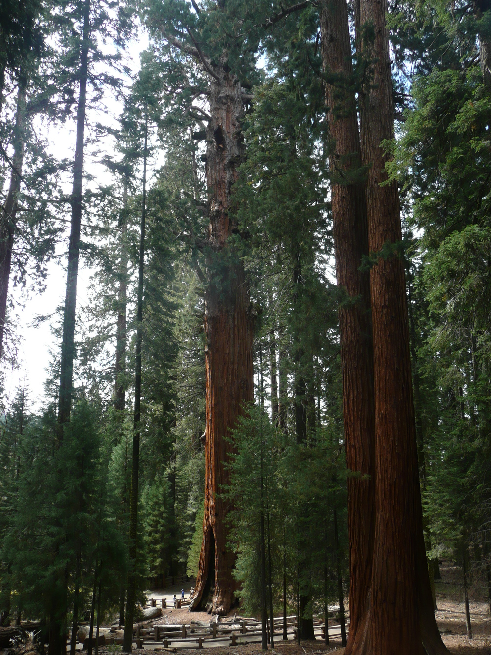
Giant Trees, Sequoia National Park
Truly on “vacation” with no cell service, I enjoy reading in the lovely John Muir lobby, built in 2000, to begin the day. We start at the Lodge Pole Visitor Center (16th stamp!) where we learn about “prescribed burns” and the demolition of the village around the giant trees – which explains to me why there was no “old lodge”. We also learn that the summers are extremely dry, thus the lack of vegetation. Thanks to the Alaskan Gulf, the weather pattern in the Sierras changes dramatically in winter. The snowpack is a key source of LA and San Francisco's water supply.
While Mom and Dad keep the humans at bay, two playful black bear cubs greet us at the entrance to our next stop, the General Sherman Tree. The “largest living thing”, this awe-inspiring 2200 year old tree qualifies based on volume (redwoods are taller). It is hard to comprehend the enormous scale - 275 feet tall and 103 feet around. We continue on to the Congress Loop to see more gargantuan Sequoia’s – House and Senate clusters, President Tree, and Lincoln Tree. The lack of undergrowth and constant smell of fire creates a unique environment on this 3 mile walk. Sequoias are impervious to disease and fire although they need fire to germinate. Their roots are shallow and trampling can kill them which is why the village was demolished.
Another stop is Morro Rock, very much like Half-dome in Yosemite. Except, this rock has 400 well engineered stairs up to the summit.
We end our fantastic day with a lovely dinner at Wuksachi Lodge built by the Park Service after the demolition of the village. Even though I enjoyed the John Muir lobby, I wish we were staying here.
Day Eight – Kings Canyon

Kings Canyon National Park, CA
Our final day, we head to Kings Canyon in the northeast section of the complex. The windy road takes us from 6500 feet at Grant Grove down to 1500 feet in the Canyon itself. As we descend, looking down into the V portion (created by a river) of the Canyon is quite spectacular. It is not nearly as steep as we approach the U shaped portion (created by a glacier). Towering granite walls surround the valley floor, very similar to Yosemite. However, there are "no" people in Kings Canyon!
“Road’s end” – literally the end of the road - is our destination. Access to the largest area in the lower 48 states without a road begins at this point. We decide to hike 4 miles out and back along the crystal clear, Kings River. All we can hear is the wind howling down the canyon and the occasional oak leaf crunching below our feet on our pleasant hike.
As we head back up the steep road, the smog rolls in. Highway 180 returns us to civilization in Fresno where we catch an early morning flight back to Seattle. My “fear of flying” success continues on my first “small plane” flight since the clinic – yeah!
With 16 parks “down”, we have 42 “to go”. We have visited all the Parks on the West Coast. The Parks are incredible and even better when shared with family and friends. A big Happy Birthday to Val – you meet such difficult obstacles with wonderful grace. Next May we head east – way east – to Acadia in Maine as our adventures continue.
Click here to see what inspires our goal of visiting all 62 National Parks and to check our progress!
And check out the National Park Gallery!

