

Walking (or Trekking) the Monterey Bay Coast - with a Daypack and Credit Card !
It’s one week away from our planned trip to walk the entire Monterey Bay coast, 50 miles. It’s heartening to see the 10-day forecast calling for mid-sixties and partly sunny the first week of November 2021.
Our hotels are all booked, yes, we are “credit card camping”. Each day we will walk about 10 miles and we can’t wait. Our biggest challenge now is to fit everything we need for a week into a daypack.
The day of departure has arrived and to begin the minimalist nature of the trip we walk one mile to the light rail from our house in Seattle, ride to the airport and then catch a flight to San Jose. A 45-minute Uber ride over a curvy Highway 17 takes us to Santa Cruz where we will start walking tomorrow.
Luckily, our hotel, the Dream Inn, let’s us check in early. It’s a great place with a fun surf motif and lovely beachside pool. Each room has a deck and view of the bay and the surfing action at Steamer Lane. I usually make the reservations, but this trip Tom did it all – big kudos!
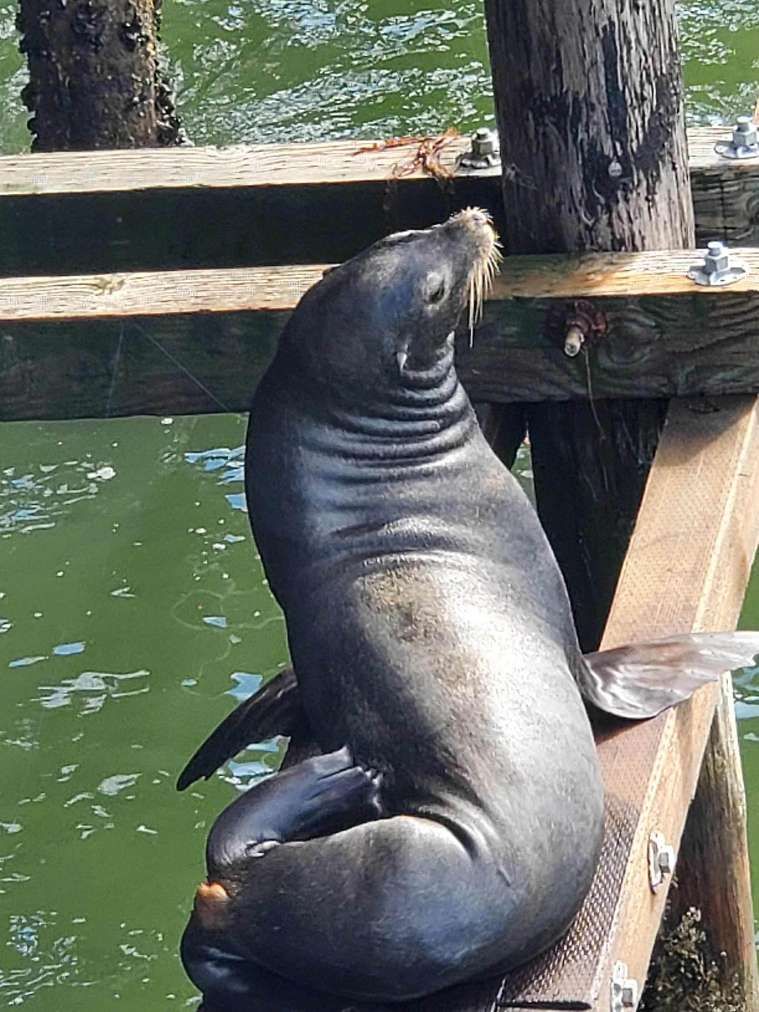
California sea lion at the Santa Cruz Wharf, CA
We begin our exploration by walking the half mile long Santa Cruz Wharf, gateway to Monterey Bay since 1914, to a lot of loud barking. California sea lions, once endangered, are now prevalent. They like to hang out on the pilings under the wharf at low tide – a real rowdy bunch.
It’s here, after lunch, we learn that the Monterey Bay National Marine Sanctuary is one of the largest in the US encompassing a much bigger area than Monterey Bay itself. The Sanctuary protects a large underwater canyon over two miles deep. Sealife flourishes!

Monterey Bay National Marine Sanctuary map
We fall asleep to the sound of crashing waves, which I love, having already walked nine miles while exploring Santa Cruz!
Day One – Santa Cruz to Aptos, nine miles (takes us 12)
We wake to sunny skies but dense fog rolls in just as my childhood friend and her husband join us for the trip and want to check out our view at the Dream Inn – oh well, no view.
Our walk begins!
We walk on the beach under the wharf heading southeast but shortly we must walk inland because of the San Lorenzo River. I am anxious get back to the beach, so we keep trying but to no avail due to headlands, thus creating some of the extra mileage for the day.
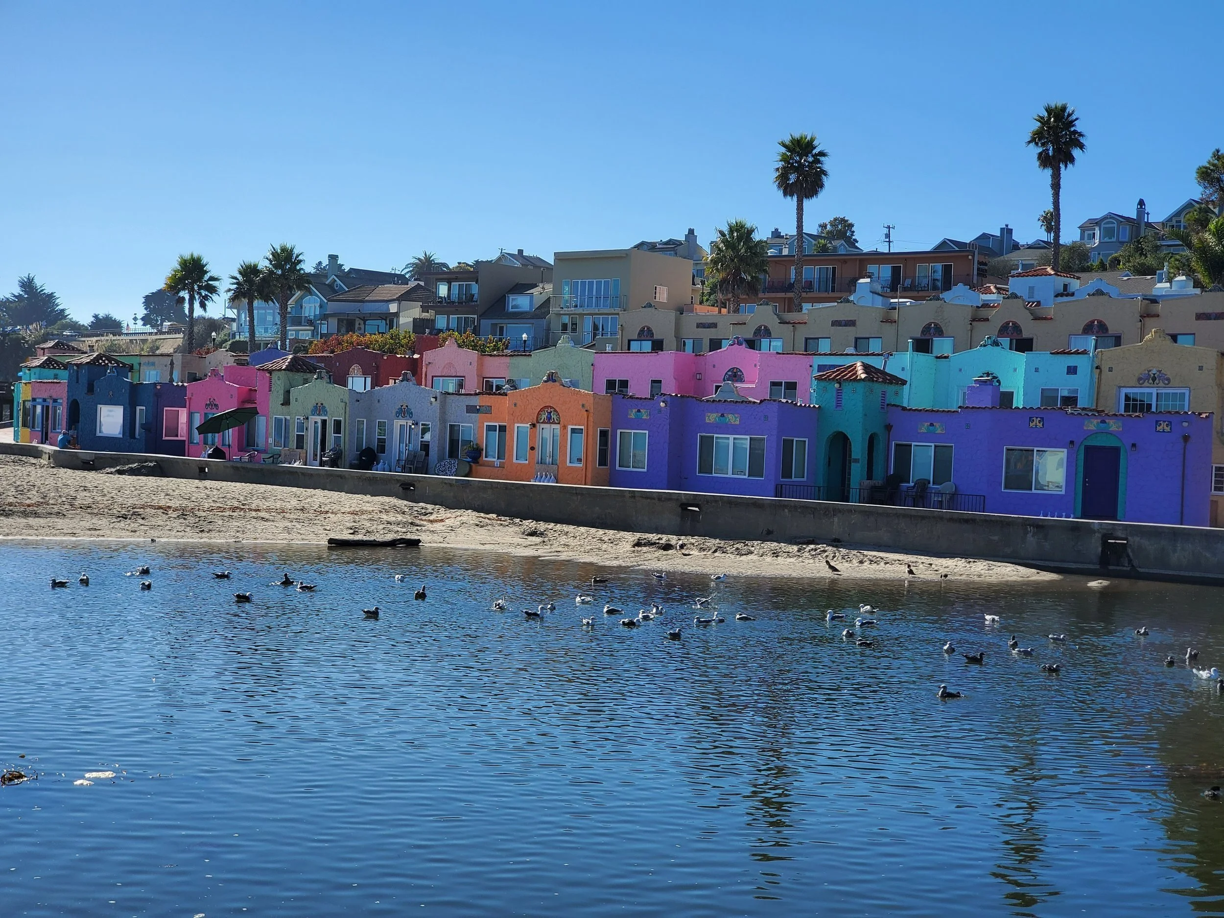
The route takes us through surf lifestyle neighborhoods until Capitola – so cool! As we approach Capitola, we all think the same thing, it feels a little bit like Europe here. Lunch on the terrace at the Paradise Beach Café could not be more scenic or tasty (fish tacos).
View from lunch at Paradise Beach Cafe, Capitola, CA
Hurray, I finally get my beach walk all the way from Capitola (tide pools) to Aptos. It’s a flat sandy beach for miles, the sun is out and it’s all so beautiful!
Once to Aptos, despite Google Maps which is super handy on this trip, we mistakenly walk UP a hill to our hotel – should have known better with a name like Rio Sands. The hotel is just two blocks off the beach and has adequate accommodations. Dinner outside at the Rio Café is convenient after a nice sunset at the beach.
Day Two – Aptos to Watsonville, 11 miles
We grab a sandwich to go from Erick’s Deli Cafe before we start walking knowing that it’s all beach, with no lunch available to buy, until Monterey.
The fog is with us again this morning, but gradually lifts. We are appreciating that fall is a wonderful time for this trek. There are virtually no people. And the weather (mid 60’s, sunny, low wind) couldn’t be better!
As we head south from Aptos, we initially pass big single-family view homes, followed by condos after which the bluffs become somewhat more natural with pampas grass and ice plants stabilizing the landscape.
The crashing waves along this flat sandy beach are magnificently mesmerizing!
Seabirds provide quite a bit of entertainment. Endangered brown pelicans cruise low along the water scoping out prey and then “boom” they dive in and grab their food. The tiny sanderlings scurry in and out on the sand, along with the waves, foraging for their food accompanied by the larger long billed curlews.

Sanderlings, Monterey Bay, CA
Today we pass multiple State Parks protecting the coastal land, so everything is quite natural. The bluffs become lower and lower as we move along.
We turn in at Palm Beach State Park and ask a State Parks employee how to get into Watsonville. He says it’s 3-5 miles on an busy agricultural road with no shoulder. Discouraged, we walk a short distance and low and behold the State Parks employee comes back with his own rig to pick us up!
The Hampton Inn is new and quite comfortable but nothing other than Starbucks is around, so we take a Courtesy Cab ride with an entertaining driver into this agricultural town for dinner. While a brew pub in a strip mall is an odd location for the Hindsight Café the food is wonderful (steamed clams and kale salad).
Day Three – Watsonville to Moss Landing, eight miles
We planned the stay in Watsonville, last night, instead of Moss Landing because we didn’t know if we could cross the Pajaro River. So, after our overpriced cab drops us off at Zmudowski Beach, on the south side of the river, we begin the .5 mile walk back north to the mouth of the river to see what we missed. Along the way, we do our part and pick up three bags of Styrofoam, the worst, and plastic.
As we get closer to the river amid flat dunes, perfect nesting grounds for the abundant snowy plover, we see sand islands in the river delta full of brown pelicans, heermann’s gulls, sanderlings and long billed curlews. We drop our daypacks, shoes and socks and walk out into the delta - tons of fun! To our surprise, even at high tide the river is shallow and easy to cross. We toe touch the other shore and return.
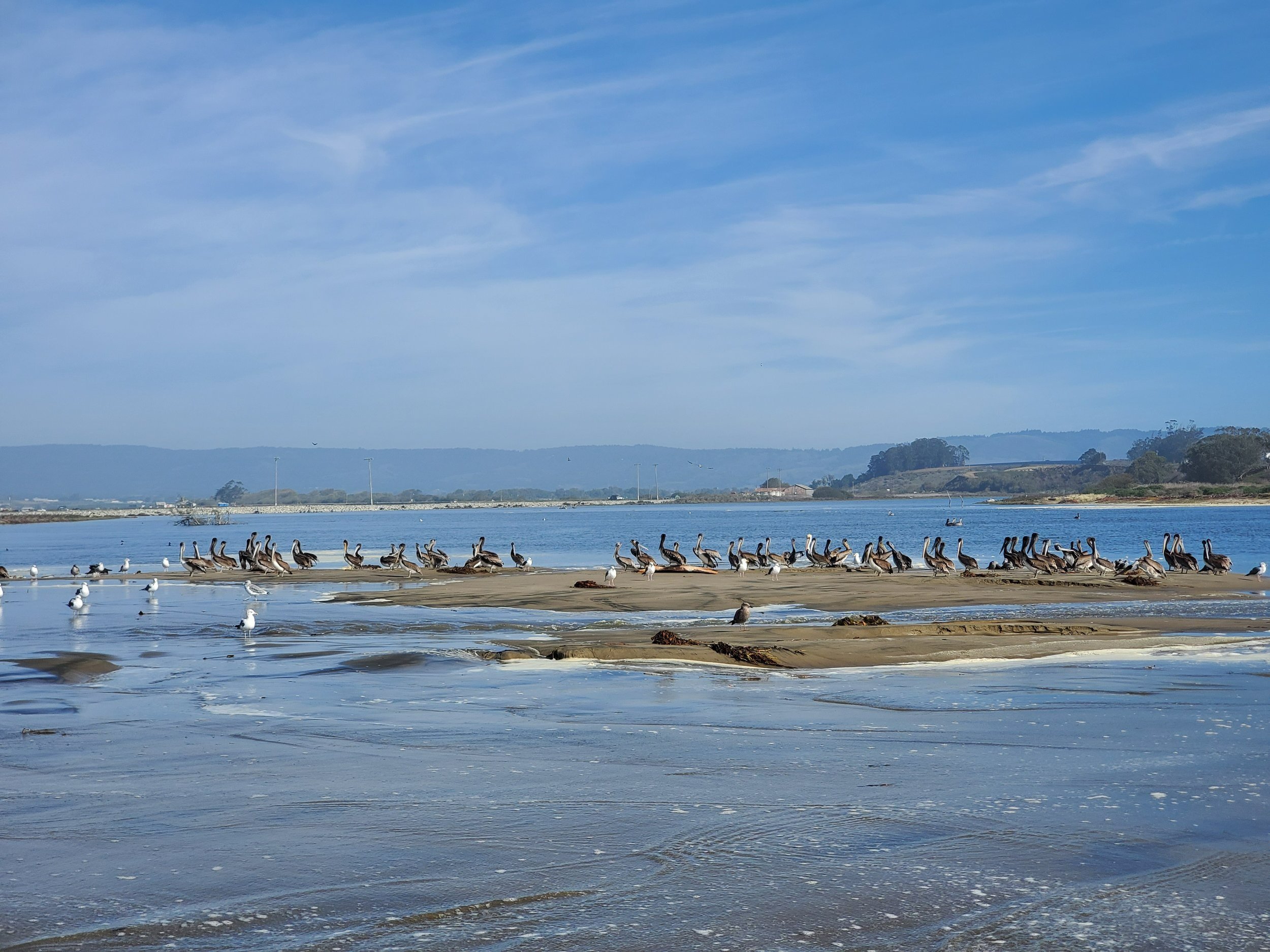
Pajaro River delta, Watsonville, CA
Gosh, we could have done the crossing (summer and fall)! Oh well, today it makes a shorter day and would have made yesterday a long 17 miles.
We start walking south again and pass our morning drop off point. Low sand dunes continue but unfortunately, thanks to the mid-day high tide, the beach is narrow and steep making walking more difficult.
Tremendous knots of giant kelp litter the beach. They can grow over a foot a day! I have never seen holdfasts (their version of “roots”) so large. No wonder they had tractors in Santa Cruz cleaning up the beaches.

Gaint kelp, Monterey Bay, CA
Happy for a shorter day we cut up at Moss Landing State Beach and walk about a mile on Highway One, yuck, to Captain’s Inn at Moss Landing tonight’s cute but overpriced lodging. Moss Landing, a population of 54, is home to Elkhorn Slough and a marina. Luckily, the Whole Enchilada is within walking distance and pretty good for dinner.
Day Four – Moss Landing to Marina, 10 miles
The day begins with coffee in our room overlooking the wetland followed by a hearty breakfast at the Moss Landing Cafe, clearly a local’s spot.
We walk back out to the beach to the south of the wetland. It’s a beautiful day; mid 60’s, clear blue sky and light wind! But the sand is coarser and the beach steeper due to the mid-day high tide again, so walking continues to be more challenging.
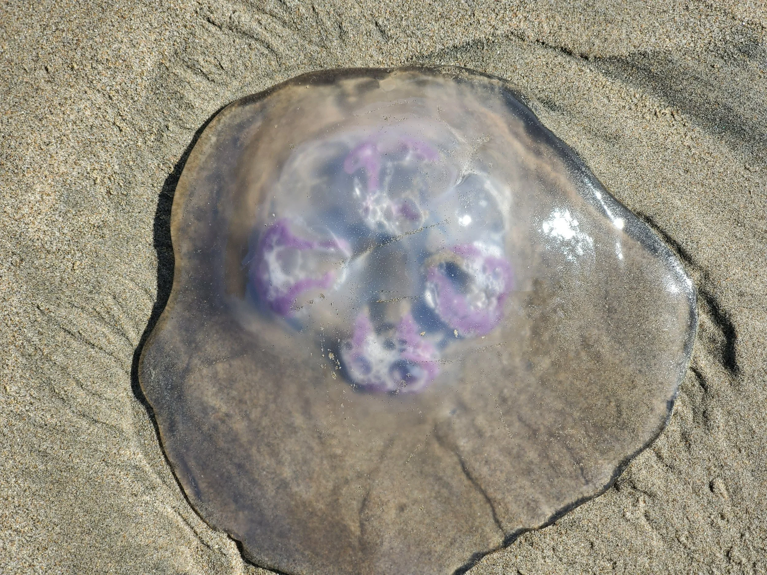
Huge moon jelly on the Monterey Bay beach nearly a foot across!
After we try the beach for a few miles we go inland, enjoying the fall color on the ice plants. We walk on the Sandholt Trail but the fine loose sand is even more difficult to walk on so we go back to the beach.
The tall blue waves are loud today as they crest, turn to white water and crash before they come ashore. We have mostly avoided getting our only shoes wet by scurrying away, just like the birds, but not always.
Knowing that we have another river crossing ahead we treat ourselves and go barefoot again. Turns out the Salinas River crossing is a non-event.
After vegetation covered low dunes all day we finally figure out where to turn in, Marina Dunes Preserve.
Our destination is the Best Western, Marina which is next to the nicest RV park I’ve ever seen. Right across the street, The Sanctuary, a high-end spa resort, satisfies us for dinner.
Day Five – Marina to Monterey, 10 miles
The easy walk back to the beach in the warm sun is met by soft sand on a flat beach again which makes walking easier – great for our last day.
Our walking rhythm has been natural. We walk all together, walk alone or walk in pairs with no plan often just zoning out. And we naturally re-group every few miles. Today is no different. We haven’t had anyplace to buy lunch since day two, so we pack snacks, stop and share.
We follow the shoreline of Fort Ord Dunes State Park, protected mid-size dunes, most of our final day.
A hang glider greets us as civilization begins to appear before arriving in Monterey.
The exit off the beach to our cute motel, Monterey Bay Lodge, is obvious. Reluctantly we turn in knowing that we must say goodbye to the beach. What a unique and peaceful adventure it has been!

Welcome to Monterey, CA after 50 miles of beach walking!
The requisite Monterey Wharf dinner concludes our fabulous adventure with good friends before they drive back to Seattle. Tom and I are staying a couple additional days in Monterey.
Our first day in Monterey we walk into town on the Monterey Bay Coastal Recreation Trail and wander around enjoying the mammals and seabirds in the bay as much as Cannery Row. We read that Point Lobos State Natural Preserve, is worth visiting so we get an Uber to Carmel for lunch – al fresco dining at Porta Bella is fab and then get another Uber to Pt Lobos. Our walk takes us out to Whaler’s Cove and Bluefish Cove as we gawk at the incredible rock formations and wildlife for about three miles. After finding wi-fi, we get an Uber back “home” to our hotel. A nice day!

Point Lobos State Natural Preserve, CA
The locals packed Monterey Fish House is quite the dining experience, especially in an un-masked covid world!? Tom’s roasted artichoke pasta is delicious!
As a conservationist and Beach Naturalist for the Seattle Aquarium, the Monterey Bay Aquarium has long been on my “bucket list”. I am excited, today, our second day in Monterey, is the day we get to go! We arrive for our 10:30 am tickets and begin with the Jellies – wow! A feeding in the Open Sea, a huge tank, follows along with Tenacles, a wonderful Cephalopod exhibit. We get to see two great movies – one on otters and one on the work of the Aquarium before we see the cute otters themselves.
We take a break and have a lovely lunch at Steinbeck Court Café outside in the sun once again! After lunch we go back to the Aquarium and explore the Kelp Forest (Giant Kelp versus Bull Kelp in Seattle), touch pools and aviary.

Sea Nettle jelly, Monterey Bay Aquarium, CA
I can see why this Aquarium is “world class”! Originally, started by David and Lucile Packard of Hewlett Packard, its mission is to inspire conservation of the ocean. Sitting right on the edge of the bay the intent is to bring the bay “in” which they do visually in addition to pumping bay water into the exhibits. The decks overlooking the bay are outstanding, especially on a clear sunny day. The presentations are simple, clear and impactful. It strikes me as a cross between an aquarium and a museum. Loved it all!
I have never walked to an airport before but on our last day , at the end of a walking trip, it feels appropriate. We approach the Monterey Regional Airport following a three mile walk, and have lunch al fresco before we fly back to rainy Seattle. After landing and taking the light rail we do the mile walk home again giving us a nice round and incredibly fun 85 miles!
Should we call ourselves trekkers or walkers now?

