

Tom's Top Ten Wildflower Hikes in Mt Rainer National Park
Mt Rainer National Park has captivated first time visitors along with frequent visitors, like Tom, for centuries. The majestic glacier clad volcano at 14,410 feet dominates the pacific northwest skyline. Up close and personal views of “the mountain” in the park leave visitors awe struck!
As impressive as the mountain itself, is the alpine area surrounding the mountain. Ancient forests cloak the lower elevations while fields of colorful wildflowers blanket the sub alpine and alpine slopes during the summer months.
After Tom, my partner, relocated to Seattle from Denver, he transitioned his love of hiking and fascination of wildflowers to the pacific northwest with Mt Rainer as a centerpiece. We are lucky to have a tiny ski condo close to the southern entrance of Mt Rainer National Park – a perfect starting point!
If you are interested in a cardio workout, Tom is not the guy to hike with during wildflower season. He is much more interested in counting how many white, yellow and purple wildflowers he saw and taking pictures. It’s a big day when he finds a wildflower he has never seen before!
Snow begins to melt in May as spring comes to Mt Rainer National Park and finally near the beginning of July the avalanche (white) and glacier (yellow) lilies give a good show in the newly exposed moist ground. Then as temperatures continue to warm sweet smelling purple lupine varieties become abundant along with the brightly colored Indian paintbrush and a myriad of other species. There are over 700 hundred documented floral species in Mt Rainer National Park. It’s simply spectacular!
Of course, the best way to enjoy these wildflowers is to hike among them. After years of doing just that, these are Tom’s ten favorite wildflower hikes in Mt Rainer National Park in order of difficulty:

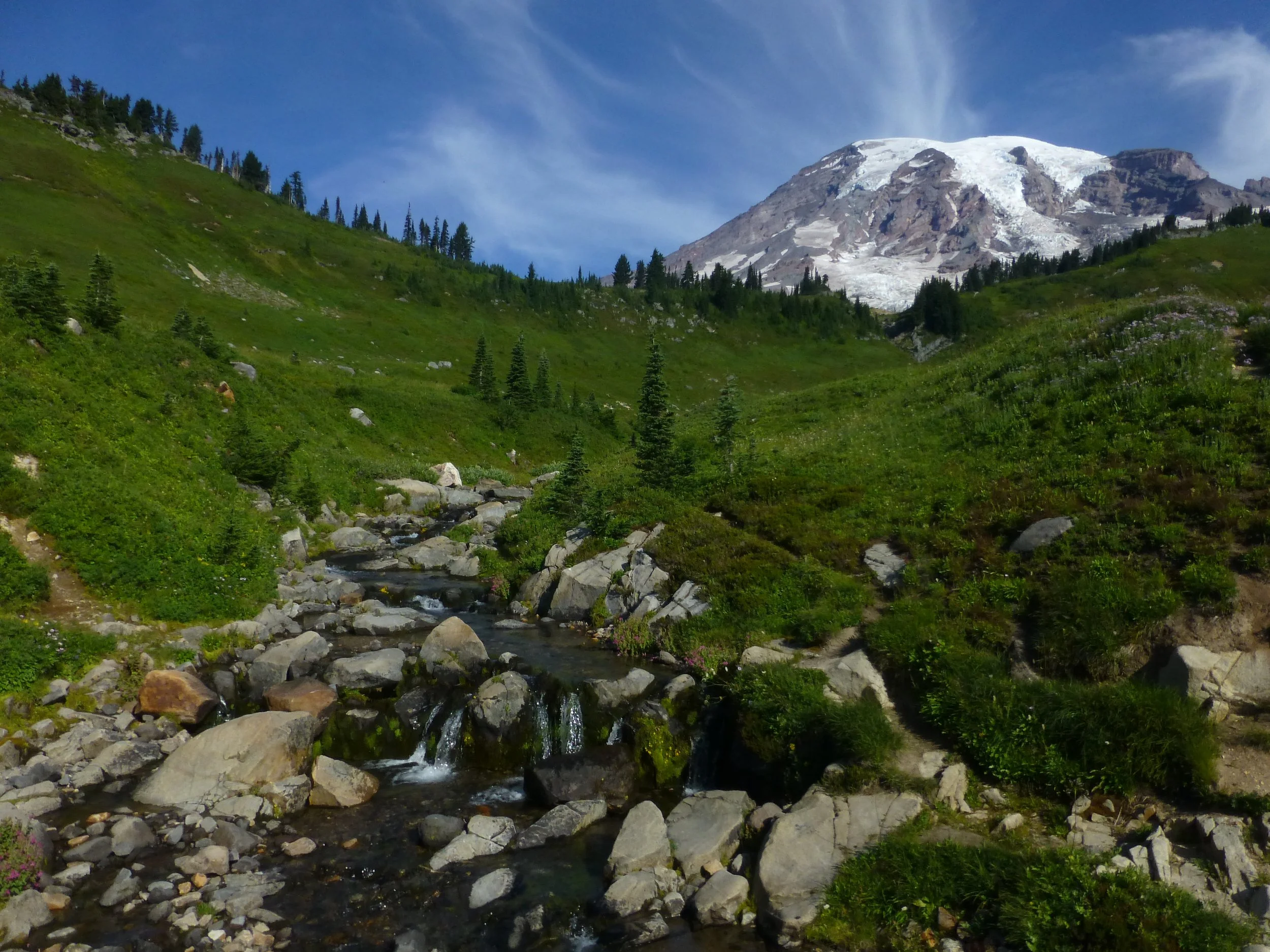
Mt Rainer from the Naches Loop Trail, Mt Rainer National Park, WA
1. Naches Peak Loop Trail - 3 miles, 600 feet
This is one of the best wildflower hikes around and accessible for most! The trail begins at the top of Chinook Pass. We like to go in a clockwise direction from the trailhead that begins to the east of the wooden bridge over Highway 410.
Immediately heather, paintbrush, lupine, and lily fields are above and below the trail. As you continue, you’ll gradually gain some elevation on a well-maintained trail. On your left you will see a little lake, our dog Molly’s favorite. After the lake you’ll gain a bit more elevation until you reach a point where you can look down upon Dewey Lake. From here you will enter park property so no dogs are allowed past this point – you can simply go back the way you came and enjoy the flowers again.
Soon you come upon an often-photographed spot looking out over fields of wildflowers and a pond to a spectacular view of Mt Rainer.
Continuing takes you back to Highway 410. It’s ok to walk on the road back to your car but more scenic to walk across the street past Lake Tipsoo, up the trail and over the wooden bridge to your car.
As expected, this hike attracts crowds. Early morning or evening are lovely and less crowded. Weekdays are better too!

Mt Rainer from Grand Park, Mt Rainer National Park, WA
2. Grand Park via Lake Eleanor Lake – 8 miles out and back, 1,100 feet (11 miles, 4,000 feet to Sunrise via Grand Park and Berkley Park - one way)
This is a fabulous hike with a park or flat field of wildflowers as the destination! Mt Rainer provides a stunning backdrop.
Turn off Highway 410 on SR 73 near Greenwater and drive 10 miles. This road has lots of washboard, but most cars do fine. Park on the side of the road where is crosses Eleanor Creek.
You will begin your hike in a dense Douglas fir forest before arriving at lovely Lake Eleanor. From here you will continue up through less densely populated vegetation and perhaps get your first glimpses of lilies. As you get closer to the first flat field, you’ll have a short steep section via some wooden steps. Enjoy the first field, where we have even seen a bear, but continue to Grand Park because it’s as grand as can be!
There is one skinny trail to walk through on this magnificent field while feasting your eyes on all the wildflowers and Mt Rainer! Go across the entire field have a snack and return the way you came. Yes, it can be buggy in summertime but well worth it.
The trail continues to Berkley Park (hike #7 below) and then up to Sunrise if you are game – car shuttle required for the longer version.

Mt Rainer from the Second Burroughs viewpoint - up close and personal. Mt Rainer National Park, WA
3. The Boroughs – 6 miles out and back 1,400 feet (Third Borough 9 miles, 2,500 feet)
Tom likes this hike to the Second Borough for true alpine (vs sub-alpine) wildflowers. These low growing wildflowers must survive harsh tundra like conditions above tree line and the three boroughs are just the place for that!
The hike to all the boroughs begins with the wooden steps going up just behind the restrooms at Sunrise. Once to the Sourdough Ridge turn left gradually ascending (views to your left and right) and follow the signs to the five-way intersection at Frozen Lake.
Once at Frozen Lake you are in the Alpine Region versus the Sub-Alpine Region. It’s very stark and you must look closely for the multitude of wildflowers in this zone, but they are there!
From here you will head to your left and ascend up to the First Borough where you will get your first up close and personal view of Mt Rainer. Continue on to the 2nd Borough ascending again. At the top of the 2nd Borough is a flat rocky spot – perfect for a snack or lunch while you gawk at the rocky crevasses on Mt Rainer.
From the 2nd Boroughs you can do another 1,100 ascent to the third Borough making the hike 9 miles and 2,500 feet. Once we even shuttled a car and hiked down to Glacier Basin.
But the most common version is to hike to the second Burroughs and just go back the way you came. For more sub-alpine flowers and different scenery take the trail you’ll see to your right back to Sunrise via Shadow Lake – it’s my favorite!
Skyline Loop Trail, Mt Rainer National Park, WA
4. Skyline Trail Loop Trail – 6 miles, 1800 feet
This is best of the best for views of Mt Rainer as well as wildflowers. The trail begins behind the Visitor Center at Paradise, so crowds are the biggest obstacle! If possible, plan this hike for mid-week or early in the day on the weekend.
Going clockwise seems best. Once past the paved paths close to Paradise you will immediately be walking through lush fields of stream filled, greenery and wildflowers. As you proceed you will begin to climb from the sub-alpine region to the alpine, above tree line.
In the middle of the climb, you may wonder when it will end but it does and it’s definitely worth it. The view of Mt Rainer and the Tatoosh Range is almost surreal it’s so beautiful!
You can go back to the way you came or follow the loop. We descended the Golden Gate trail off to the right. While steep, the wildflowers were well worth it and it avoids some of the crowds!

Comet Falls, Mt Rainer National Park, WA
5. Van Trump Park – 6 miles out and back, 2,200 feet (Comet Falls - 3 miles out and back, 1,300 feet)
This is the only one of Tom’s favorites that begins on the south side of Mt Rainer. The trail begins at a well signed Comet Falls Trailhead about 3 miles up from Longmire on the way to Paradise – where a waterfall is visible from the road.
The hike begins in a Douglas fir forest, common around Mt Rainer. In about 1.5 miles you will enjoy gorgeous Comet Falls cascading down 300 feet. From here you will take several switchbacks to the top of the falls.
From the top of the falls, it’s less than a mile to Van Trump Park, named after an early explorer! In addition to the rocky and moist fields of wildflowers you get a full-on view of the south side of Mt Rainer.
Because many visitors aim for Paradise, just up the road, they miss this great hike.

Tiger Lily on the Silver Creek Trail, Crystal Mountain, WA
6. Chinook Pass to Crystal Mountain Resort, one way – 9 miles, 1400 feet
This hike is a stunner! It begins at spectacular Chinook Pass, includes gorgeous Sheep Lake and crosses majestic Sourdough Gap before crossing the west facing slopes down to Crystal which are prime wildflower habitat.
Unfortunately, you will need to shuttle a car on this one. Do not forget your keys. We forgot them once! From Crystal drive back down to Highway 410 and enter the Park, drive eight miles to the top of Cayuse Pass and then follow the signs to Chinook Pass, another three miles.
If you have time, enjoy Lake Tipsoo and Naches Loop (see hike #1 above), especially if the wildflowers are blooming. We like to park at the top of Chinook Pass, across Highway 410 from the trailhead. There is a restroom in the trailhead parking lot.
The hike begins on flat switchbacks in full sun and continues up through the forest to picturesque Sheep Lake at about 2 miles. Take a little time to enjoy the lake before climbing up to and over Sourdough Gap. I always like to eat my sandwich at Sourdough Gap while taking in the incredible views to the south and north!
From here you will be on south facing slopes until Bear Gap, a five-way intersection. We often chat with thru hikers on the Pacific Crest Trail at Bear Gap – such fun. We generally go down to Crystal via the Silver Creek Trail – Henskin Lake or Bullion Basin are longer options.
The rest of the hike is primarily downhill crossing fantastic fields of wildflowers among rock outcroppings.
You can also do this hike from Crystal to Chinook Pass.
Once back to Crystal do not forget to go get your car!

Berkley Park, Mt Rainer National Park, WA
7. Berkley Park – 8 miles out and back, 1,700 feet
I prefer not to go downhill and then up hill on a hike but if you want to enjoy the wonders of Berkely Park you will do just that beginning at Sunrise. Or you can continue after reaching Grand Park, (hike #2 above) to Berkley Park ending at Sunrise but that involves shuttling a car. (Or vice versa.)
You will descend on long switchbacks into a bowl of greenery which is visible from Sunrise. Once down into the trees and among the small creeks is where the wildflower fun begins – enjoy, it’s one of the best there is!
Continue down to Berkely Park which is to your right (vs the Wonderland Trail) remembering that it’s up on the way back. After being satiated, just turn around and go back up the way you came down. It often looks like a different hike the opposite direction – you will see new things!

Avalanch lillies on the way to Spray Park, Mt Rainer National Park, WA
8. Spray Park – 8 miles out and back from 1,700 feet
This is an iconic Mt Rainer wildflower hike – Tom has taken many people on this one! It’s akin to a beautifully designed rock garden.
After 17 miles on a gravel road the trail begins at Mowich Lake Campground. While the drive can be arduous with terrible washboard and potholes, most cars do fine.
As often is the case the trail begins in dense forest on a flat trail. Take a left at the first signed junction.
About two miles in there is a short spur trail to Spray Falls – take it! A mile of steep switchbacks begin after the falls along Grant Creek.
As you leave the Creek the trees begin to open up to the lovely heather encrusted wildflower meadows. There is one fantastic meadow after another until you’ll see Mt Rainer in all its grandeur fronted with Echo Rock and Observation Rock.
You can continue on to Seattle Park, also incredibly gorgeous but many turn around in the middle of Spray Park at about 4 miles – it’s marked by a cairn.
After taking it all in, return the way you came.

Lupine and bear grass on the Palisades Lake Trail, Mt Rainer National Park, WA
9. Palisade Lakes – 7 miles, out and back, 1,800 feet
Here we go again, got to go down and then go up on the way out – not my fav but well worth it! Wildflowers, lakes and vistas abound!
The trailhead begins at the Sunrise Point on the way up to Sunrise. The good news is that most are anxious to get to Sunrise so the crowds on this hike are limited!
The first lake you will encounter is Sunrise Lake followed by Clover Lake at 1.5 miles. Tom, Dick and Henry Lakes follow. The .5-mile side trip to Hidden Lake is well worth it!
On the way to Palisades Lake, you will hopefully encounter sweet smelling lupine along with cherished Pika. Once to Upper Palisades Lake heavenly wildflowers abound.
Enjoy and then simply return the way you came in but get ready for the uphill at the end!

Summerland, Mt Rainer National Park, WA
10. Summerland – 9 miles, out and back, 2,000 feet (add Panhandle Gap 12 miles, 3,000 feet)
This Mt Rainer hike has it all – old growth forest, wildflower meadows, incredible mountain vistas and it’s a segment of the Wonderland Trail, an incredible 93 miles trail that circumnavigates Mt Rainer!
The trailhead is on the far side of the bridge crossing the Frying Pan Creek on the road up to Sunrise.
The hike begins on a level, well maintained trail through an old-growth forest. Sun is a bit hard to come by so the wildflowers are minimal. In a quarter mile the trail joins the south portion of the Wonderland Trail - it’s always fun to talk with thru hikers.
Gradually the trail becomes steeper and the dense forest transitions. You will cross a couple small streams and then continue onto a rocky switchback where Frying Pan Creek is rushing through the rock below the trail – once on top you can look down for a good view of the rapids. Eventually, you will cross Frying Pan Creek on a flat log.
Switchbacks take you up to the incredible and often sweet-smelling meadow called Summerland. Little creeks from snow melt are often prevalent laced with lupine, paintbrush, columbine, monkey flowers and/or penstemon depending on your timing. Marmots are regularly seen in this area – we’ve seen several large cuties. And occasionally you’ll even see a bear.
Once satiated by stunning grassy meadows of Summerland another 1.5 miles and 1,000 feet takes you to another world at the ridge called Panhandle Gap where melting snow, gravel and rock are prevalent – tread lightly. Feast your eyes to the south on the Goat Rocks, Mt Adams and Mt Hood on a clear day. You might even see a goat here!
If you go:
Timed entry reservations are required at Mt Rainer Naitonal Park for certain destinations on specific dates and specific times! Click here for inormation and reservations.
Crystal Mountain Ski Resort (CM) operates a shuttle service.so you can park at CM and shuttle to Sunrise. Click here for more information and tickets.
Peak wildflower season is mid-July through mid-August. depending on the year.
“Leave no trace”, the ecosystem is fragile! To avoid crowds hike early in the day and during mid-week, if possible.
Be sure to consult the weather. Our favorite is the NOAA site.
Check Mt Rainer National Park for conditions and updates. Road closures are not unusual.
Bring the ten essentials including extra layers. Weather changes quickly in the mountains.
Some of the slopes are exposed to the sun and hiking can get hot. Make sure to bring plenty of water!
Remember that you are hiking at altitude, 5000-7000 feet.
Your camera (or phone) is a must!
For more information about the hikes above check out WTA.org
Wildflowers of Mt Rainer by Laird R Blackwell is an excellent resource.
FlowersofRainer.com is a great resource on line.
All the photos were done by Tom, except one!
You might also like

